Tuesday, May 31, 2011

sunny day today

yet another beautiful day in paradise-dise

seas are ~3m peak to trough today... like 2 days ago, but i have sea
legs now, so i am not sea sick. totally sunny and a great view. we are
a little further offshore than yesterday, so i cannot see land
sticking up over the horizon anymore.

we are making great progress on mapping. yesterday we had to stop for
an hour to wait for some fishing boats to get out of the way and we
had to go back to fill some holidays (areas we did not map) because of
other fishing boats and also our pos-mv (our positioning unit that
tells the mapping/sonar system where we are) went out for a moment.
these delays added several hours to our survey.

here is a pic of me sending out an XBT. we drop this device (lead
'dart' with a copper wire attached) to measure the sound velocity
profile. the sound velocity profile varies with temperature and
salinity primarily. sound velocity is important as the timing of the
sonar pings through the water column is how we can tell where the sea
floor is and therefore how we can map the bathymetry.

Monday, May 30, 2011

bathymetry mapping

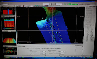
here is a shot of the software we are using to manage the sonar
mapping. basically, color designates depth. blue is deeper than red.
the blue is the Juan de Fuca channel offshore Washington. this channel
feeds turbidity currents that have been cored in the past to document
the earthquake history of earthquakes on the Cascadia subduction zone.

3.5 kHz logging example

here is an example of the 3.5 kHz CHIRP logging that we are doing here
offshore WA.

i mentioned this log in a previous post. depth is marked on the right.
i have labeled two units, a lower more sandy unit i am interpreting as
tubidites. the upper unit is either a series of muddy turbidites or
simply just mud. i suspect there are turbidites here, as i see some
faint reflections (difficult to see in this image).

this was taken in an arm of the Juan de Fuca Channel at approximately
N 47 24.5424 W 125 23.5226. the channel is colored blue in the next
image i will post.

survey area

here is a shot of some of the surveying (just a small portion) that we
are up to...

the orange lines are the areas we plan on surveying first. pink stars
are the ocean bottom seismometer draft locations. once we survey the
bathy and sub bottom, we will know how we might need to change the
locations...

oregon and ca will come next. more later,,, got a good shot of the 3.5 data...

at sea

we are under way and collecting excellent bathymetric and sub surface
data. yesterday i spent being sea sick as the seas were rough and i
usually get sick the 1st day. pam of the ship's crew provided me with
some bonine and i am now feeling much better, back to 110%!!!

ill post a pic of the bathy and 3.5 kHz screens later today to show
you what we see when we are collecting data. currently, we are
transiting across a wide channel that has a nice record of turbidites.
looks like there is a package of mud (~10m thick) overlying turbdites
of at least ~30m thickness. the mud is probably the holocene and the
turbidites probably represent the pleistocene (which had a much higher
frequency of turbidite deposition). this interpretation is not based
on any core data and is purely hypothetical! the mud package may
actually be turbidites that are muddy and have little density contrast
to show up on the subsurface data.

buddy shane is applying for the mariner position at COAS (soon to be
CEOAS, welcome geoscience buddies!). here is the link to the wecoma
page: http://www.shipops.oregonstate.edu/ops/wecoma/ and the link to
the elakha page: http://www.shipops.oregonstate.edu/ops/elakha/

here is the live web cam for the wecoma: http://webcam.oregonstate.edu/wecoma/

the wecoma does local research, as well as global research. it was
recently in hawaii. where it goes is based on the requests of
researchers and who gets it. the elakha generally stays local as it is
a much smaller boat. good luck to shane.

more later, j-j

Saturday, May 28, 2011

locks

here is a shot from the locks...

heading to sea...

well, the fine shipboard engineers, led by terry, got the ship running
on their estimated schedule. we left dock before 17:30.... i awakened
from a nap at 5:44 and we were in the locks... i had 15 mins to get
dinner and the cook sarah had made me a custom mushroom risotto just
for me! she is the bomb. i am so lucky to have such a kind cook on
this cruise!

we were quite the spectacle to memorial day tourists at the locks.
many photos taken of our ship and us... and i got a few shots of them
too...

we are now in puget sound and are heading north to the strait of juan
de fuca. N47 42.8176 w 122 25.4833 is our position right now. now it
is not, lol.

we are already logging bathymetry and the res techs (computer and
technology crew from the U/W crew) are working on getting the 3.5 kHz
chirp running. it is currently not recording the heave (the ship
motion going up and down). the heave is important to remove from the
measurements to have a 'correct' bottom and depth measurement.

we expect to hit the mouth of the strait around 5 or 6am... my shift
is from 8am to 4pm, so i will begin my shift a little early to make
sure we get off on the good foot, just like james brown would say.

sailing off into the sunset~~~~

further delayed with generator

we are further delayed. instead of simply a fan hitting a fan housing
making a noise, the fan's set screws were sheared off. as the access
is rather limited around this equipment, our new departure time is
around 17:30. so, we are granted more time to plan with chris
goldfinger on the ship.

chris g is not participating in the cruise and will help us make
decisions remotely. instead, the ever able chris romsos will be the
chief scientist (or "PI") for this cruise. chris r (cromsos) is as
nervous as i would be, but i am confident that he will do a great
job!!! chris g would not have placed him as chief scientist if he did
not think that cromsos would succeed superbly.

ok, back to work waiting... cheers, jay

delayed momentarily, but heading to sea soon

we performed a compass calibration today ("spinning the compass"). as
we left dock, the engineers determined there was a problem with the
generator being used to power the z-drives. the ship uses generators
to make electricity to run the electric motor driven propellers. we
went back to dock to fix this problem, and we will be leaving soon.

we just had our safety meeting (safety first) in the main lab. the
science party is really small (six), so it was a short meeting. the
science crew was about 36 for the sumatra cruise, so there will be
plenty of personal space on this cruise.

right now, it is time for lunch.

Friday, May 27, 2011

at dock, U Washington, R/V Thomas G. Thompson

we have set up our computers and are working out the bugs (software
licenses, etc.). there are some new systems on board, so we will be
learning how to optimize these as we go along.

the old chirp was a knudsen 320B, but now we have a 3206 chirp. the
software in quite improved, so it is a little different that before.
there are also some additions to the multibeam system (for sonar
mapping of the seafloor topography, etc.).

chris romsos is the chief scientist and he is well prepared to lead us
on our journey. it looks like that after we go through the strait of
juan de fuca, we will head north to get some bathymetry etc. on the
outer shelf/upper slope offshore vancouver island. following that, we
will head south to collect vast amounts of data offshore washington,
where there is scant existing bathymetry.

ill try to get another map up to show everyone where we are... ill
post lat longs, etc. as we go. cheers, jay

Wednesday, May 25, 2011

leaving for Seattle in the morning.

in the morning, i leave for seattle, wa with my group from oregon
state university, college of oceanic and atmospheric sciences COAS,
active tectonics and seafloor mapping lab.

we will be mapping the sea floor topography (bathymetry) and
sub-surface (3.5 kHz CHIRP) off the coast of wa/or/ca/can. one goal is
to provide site information for the placement of ocean bottom
seismometers as part of the cascadia initiative. another goal is to
provide information for ocean observatories being designed in these
regions. an added benefit is that we will learn about vast areas that
have been previously unmapped to this detail. there are many
opportunities for discovery. my responsibilities will be to keep the
seismic equipment working and creating useful data.

look forward to regular posts, probably either stream-of-consciousness
or scientific in nature, or both. i will try to post maps of what we
are doing so you can all see what we are learning while at sea.

i also hope to rewrite a paper (on sumatra submarine
paleoseismology)and possibly begin a two new papers (on sumatra
submarine paleoseismology and terrestrial cascadia paleoseismology).

ill try to post on facebook when i update thus blog, but the internets
may occasionally be of limited bandwidth.

blessings, jay patton